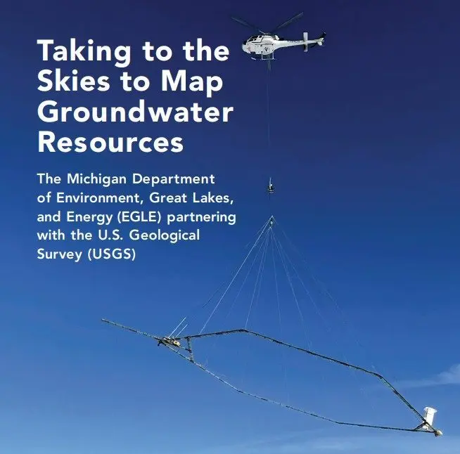
Southwest Michigan residents may soon notice helicopters carrying 60-foot wide sensor hoops flying around the region.
The flights are part of a U.S. Geological Survey and Michigan Department of Environment, Great Lakes, and Energy collaboration to study groundwater in several counties. EGLE Groundwater Data Unit Supervisor Sydney Ruhala tells us the helicopters will be towing the large hexagonal sensor hoops to scan the terrain.
“The helicopter tows a large — it looks like a hula hoop, but it’s really large and it has these electromagnetic sensors attached to the hoop,” Ruhala said. “And the helicopter will fly at relatively low altitudes, several hundreds of feet above the ground surface.”
As the helicopters pass over, electronic signals will be bounced back to the choppers so researchers can see what’s below ground.
“Essentially what it does is it’s measuring what’s called the electrical resistivity of the subsurface. So it can tell us, when you look at the resistivity, it can tell us about the types of materials beneath the ground surface. So whether you have sands and gravels, or if you have clays. It can also tell you about the bedrock, so the consolidated rock material that you have underground. And it essentially allows us to create a 3D map of the subsurface that then we can use it to study our groundwater resources across the region.”
Ruhala says having a better understanding of groundwater can lead to better resource management.
“Michigan residents, probably about 40%, I want to say, of Michigan residents rely on groundwater for drinking water. We also use groundwater in a lot of other industries. People use it for irrigation. You can withdraw groundwater for industry like non-contact cooling water. Groundwater is also important in the water cycle. It connects to our surface water bodies so it’s important for our ecosystems.”
The helicopters will be flying about 200 feet above ground and covering areas in a sort of grid pattern. They’ll avoid flying over people and buildings.
“You’ll probably see them overhead flying in their path. They won’t make large circles or anything like that. They’re pretty much straight lines that they follow. They’ll do their best to avoid flying over people, areas with lots of animals, things like that. The technology is safe. It does not cause any harm to plants or animals or humans. It’s safe technology.”
This isn’t the first time the U.S. Geological Survey has conducted this kind of surveying in Michigan, as Ruhala notes they recently did it in Kalamazoo and the U.P. This time around, the scans will be done in several Southwest Michigan counties, including Berrien, Cass, and Van Buren.
“After the fact, once the data is processed, the United States Geological Survey will release that data publicly. It’ll be available through their science base. And then we’ll continue to use that to make interpretations moving forward once it’s available.”
The flights will start around the second week in April and continue for the next few months. You can learn more about the scans right here. You can also track the flights, once they start, right here.